
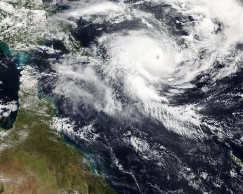
Severe Tropical Cyclone Maila has intensified into a formidable category five storm while hovering over the Solomon Sea, poised to make landfall on the far north Queensland coast of Australia early next week. This intensification comes just weeks after the same region faced the brunt of Severe Tropical Cyclone Narelle, which struck on March 20 as a category four system. Maila was situated over the Solomon Sea as of Wednesday, with the Bureau of Meteorology (BoM) predicting it will impact the Cape York peninsula, likely on Monday.
Impending Landfall and Potential Impact
According to BoM senior meteorologist Ilana Cherny, the cyclone is anticipated to make landfall between Lockhart River and Cairns, following a trajectory akin to that of Cyclone Narelle. "There's still a range of possibilities in terms of how fast the system will move towards far north Queensland, but at this stage, it's likely to cross the coast early next week - most likely later on Monday," Cherny stated. As the cyclone approaches, Queensland communities may start experiencing effects over the weekend, which could include heavy rainfall, increased flood risks in already saturated areas, strong winds, and dangerous surf conditions. Originally reported by The Guardian.
Intensity and Comparisons to Previous Storms
Maila's minimum pressure has been recorded at 924 hPa, which is lower than Narelle's 930 hPa, suggesting a greater storm intensity. Although Cherny mentioned that Maila is expected to weaken as it moves southwest towards Australia, significant impacts are still on the horizon. "That's certainly one of the significant watch points over the next few days," she added. As communities brace for potential devastation, the cyclone's effects were already being felt in the Solomon Islands, where social media images depicted destruction in remote areas, particularly in the Western and Choiseul provinces.
Seasonal Context and Historical Comparisons
This marks the seventh storm this Australian cyclone season to reach severe tropical cyclone strength, defined as category three or higher. The cyclone season runs from November to April and, according to BoM data going back to 1980, only three or four out of ten tropical cyclones typically make landfall each season. This season, Maila is now expected to be the seventh cyclone to strike the Australian mainland, with predictions indicating it will be the third to cross the Queensland coast. Earlier this season, Tropical Cyclone Koji was downgraded to a tropical low just prior to impact in January, while Narelle notably made landfall in three of Australia's states and territories-an occurrence not seen in over two decades.
Concurrent Storm Systems and Climate Insights
While Maila poses a significant threat to Australia, another storm system, Severe Tropical Cyclone Vaianu, is also making headlines. As of Wednesday, Vaianu was a category three cyclone situated approximately 400 km southwest of Nadi in Fiji. Cherny noted that, as often seen, Vaianu is expected to weaken as it moves out of the tropics before transitioning into an extra-tropical cyclone on Friday, tracking towards New Zealand where it could hit the North Island with potentially life-threatening winds over the weekend.
Climate experts, such as Liz Ritchie-Tyo, a professor of atmospheric sciences at Monash University, have been monitoring the patterns of cyclone formation closely. Both Maila and Narelle developed near the equator, where they are often steered westward towards Australia due to specific circulation patterns. Ritchie-Tyo pointed out that while global heating may lead to a decrease in the frequency of cyclones, those that do form are becoming increasingly intense. Preliminary observations indicate that cyclones are moving slower and, as a result, the impacts felt on land last longer. "Adaptation becomes really important because it might not be about what the most intense wind speed is - it might be about how long those winds stay strong and how far inland they stay strong," she emphasized.
As Cyclone Maila approaches Australia, residents are urged to stay informed and prepared for severe weather conditions. The impact of such powerful storms not only threatens immediate safety but also raises significant concerns regarding long-term climate-related adaptations in vulnerable areas.
Originally reported by The Guardian. View original.